


The Tsa de l'Ano is a mountain of the Swiss Pennine Alps, located east of Les Haudères in the canton of Valais. It is separated by the Col de Mourti (3,259 m) from the Pointes de Mourti to the southeast, on the range between the valley of Hérens and the Moiry Glacier (part the Val d'Anniviers). To the north of the main summit is the secondary peak of Pointe de Moiry (3,303 m), which is separated by the Col de la Couronne from the Couronne de Bréona (3,159 m).Tsa de l'Ano is reached from the Swiss Alpine Club's Cabanna de Moiry (2,825) by traversing the Moiry Glacier and ascending to Col de Moiry; Pointe de Moiry is more easily reached via its southeastern flank, the ridge connecting the two peaks is comparatively difficult. Both peaks are relatively little frequented by alpinists. An easier ascent to Tsa de l'Ano (but mostly without any marked paths) is via its western ridge from Salay (Ferpècle, 1,766 m).
 Couronne de Bréona
2 km
Übersetzt von Google Anspruchsvoller Aufstieg lang genug erstaunliches Panorama Orig... Pointe de Bricola
2 km
Beutiful climb during summer. Recommend to start the glacier trail as early as 4am to... Punta di Bricola
2 km
La Punta di Bricola è una montagna delle Alpi del Weisshorn e del Cervino nelle Alpi ... Pointe de Bricola
2 km
Pointe de Bricola är en bergstopp i Schweiz. Den ligger i distriktet Hérens District ...
Couronne de Bréona
2 km
Übersetzt von Google Anspruchsvoller Aufstieg lang genug erstaunliches Panorama Orig... Pointe de Bricola
2 km
Beutiful climb during summer. Recommend to start the glacier trail as early as 4am to... Punta di Bricola
2 km
La Punta di Bricola è una montagna delle Alpi del Weisshorn e del Cervino nelle Alpi ... Pointe de Bricola
2 km
Pointe de Bricola är en bergstopp i Schweiz. Den ligger i distriktet Hérens District ...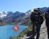 MultiRando - Pierre Burnier, Accompagnateur ...
4 km
Randonnées accompagnées dans l’authentique val d’Hérens mais aussi dans tous le Valai... Grande Dent de Veisivi
5 km
Très belle montagne avec des paysages à couper le souffle. Übersetzt von Google Sehr...
MultiRando - Pierre Burnier, Accompagnateur ...
4 km
Randonnées accompagnées dans l’authentique val d’Hérens mais aussi dans tous le Valai... Grande Dent de Veisivi
5 km
Très belle montagne avec des paysages à couper le souffle. Übersetzt von Google Sehr... Balcon du Val D'Hérens
5 km
Wir hatten einen wunderbaren Aufenthalt bei Patricia! Die Einrichtung der Wohnung ist... Roc Vieux
5 km
Roc Vieux är en bergstopp i Schweiz. Den ligger i distriktet Hérens District och kant...
Balcon du Val D'Hérens
5 km
Wir hatten einen wunderbaren Aufenthalt bei Patricia! Die Einrichtung der Wohnung ist... Roc Vieux
5 km
Roc Vieux är en bergstopp i Schweiz. Den ligger i distriktet Hérens District och kant... Balcon du Val d'Hérens
6 km
Wir hatten einen wunderbaren Aufenthalt bei Patricia! Die Einrichtung der Wohnung ist... Les Manzettes
6 km
Les Manzettes är en bergstopp i Schweiz. Den ligger i distriktet Hérens District och ... Aiguille de la Tsa
7 km
Übersetzt von Google Tsa-Nadeln. Majestätisch. Punkte oberhalb von Arolla. Arolla ist... Aiguille de la Tsa
7 km
Übersetzt von Google Tsa-Nadeln. Majestätisch. Punkte oberhalb von Arolla. Arolla ist...
Balcon du Val d'Hérens
6 km
Wir hatten einen wunderbaren Aufenthalt bei Patricia! Die Einrichtung der Wohnung ist... Les Manzettes
6 km
Les Manzettes är en bergstopp i Schweiz. Den ligger i distriktet Hérens District och ... Aiguille de la Tsa
7 km
Übersetzt von Google Tsa-Nadeln. Majestätisch. Punkte oberhalb von Arolla. Arolla ist... Aiguille de la Tsa
7 km
Übersetzt von Google Tsa-Nadeln. Majestätisch. Punkte oberhalb von Arolla. Arolla ist...Fügen Sie diese Karte zu Ihrer Website hinzu;

Wir verwenden Cookies und andere Tracking-Technologien, um Ihr Surferlebnis auf unserer Website zu verbessern, Ihnen personalisierte Inhalte und gezielte Anzeigen anzuzeigen, unseren Website-Verkehr zu analysieren und zu verstehen, woher unsere Besucher kommen. Datenschutz-Bestimmungen
