


The Engadin or Engadine is a long high Alpine valley region in the eastern Swiss Alps located in the canton of Graubünden in most southeastern Switzerland with about 25,000 inhabitants. It follows the route of the Inn from its headwaters at Maloja Pass in the southwest running roughly northeast until the Inn flows into Austria, one hundred kilometers downstream. The En/Inn subsequently flows at Passau into the Danube, as the only Swiss river to drain into the Black Sea. The Engadine is protected by high mountain ranges on all sides and is famous for its sunny climate, beautiful landscapes and outdoor activities.EtymologyThe Romansh toponym Engiadina was first attested as Latin vallis Eniatina in AD 930. A derivation from the reconstructed ethnonym *Eniates (with a Celtic suffix -ates denoting "settlers, inhabitants", as in Licates or Atrebates) has been suggested, with the first part of the ethnonym in turn containing the name of the En (Aenus (Enus)).GeographyThe Engadine lies at the most southeastern end of Switzerland and at the western end of the Eastern Alps and constitutes the Swiss part of the -long valley drained by the En/Inn until it turns northeast again after a large bend to northwest just before Landeck in Austria (the Austrian part is simply called Inntal aka Inn Valley). From the Maloja Pass (1815m) to the border of the Austrian Tyrol just before the Schergenbach, coming from Samnaun, enters the Inn, it runs for the whole Swiss length of always above in elevation.
 Engiadina
0 meter
The Engadin or Engadine is a long high Alpine valley region in the eastern Swiss Alps... Engadin
0 meter
Engadin är en lång dalgång i kantonen Graubünden i östra Schweiz. Dalen sammanfaller ... Unterengadin
0 meter
Het Engadin, is een van de hoogste bergdalen van de Alpen. Het ligt in het Zwitserse ... Oberengadin
0 meter
Engadin er dalen til Inn mellom Malojapasset i sørvest og Finstermünz, der Inn krysse... Engiadina bassa (region, CH-GR)
0 meter
Engadin är en lång dalgång i kantonen Graubünden i östra Schweiz. Dalen sammanfaller ... Unterengadin
0 meter
Das Unterengadin ist der untere Teil des schweizerischen Inntals. Gemeinsam mit dem S... Lower Engadine
0 meter
The Lower Engadine is part of the Engadine, traversed by the river En and located at ... Beverin
354 meter
Der Beverin ist ein linker Nebenfluss des Inns im Oberengadin, einem Hochtal des Schw...
Engiadina
0 meter
The Engadin or Engadine is a long high Alpine valley region in the eastern Swiss Alps... Engadin
0 meter
Engadin är en lång dalgång i kantonen Graubünden i östra Schweiz. Dalen sammanfaller ... Unterengadin
0 meter
Het Engadin, is een van de hoogste bergdalen van de Alpen. Het ligt in het Zwitserse ... Oberengadin
0 meter
Engadin er dalen til Inn mellom Malojapasset i sørvest og Finstermünz, der Inn krysse... Engiadina bassa (region, CH-GR)
0 meter
Engadin är en lång dalgång i kantonen Graubünden i östra Schweiz. Dalen sammanfaller ... Unterengadin
0 meter
Das Unterengadin ist der untere Teil des schweizerischen Inntals. Gemeinsam mit dem S... Lower Engadine
0 meter
The Lower Engadine is part of the Engadine, traversed by the river En and located at ... Beverin
354 meter
Der Beverin ist ein linker Nebenfluss des Inns im Oberengadin, einem Hochtal des Schw...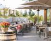 Restaurant Piste 21
891 meter
Academia Engiadina
2 km
Die Academia Engiadina in Samedan ist eine gute Schule mit engagiertem Lehrpersonal. ... Quadratscha
2 km
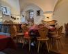
Restaurant Café Laager
2 km
Super leckeres Essen Suppe und Salat, grosse Portionen, tolles Preis-Leistungsverhält... Samaden
3 km
Samedan är en kommun i den schweiziska kantonen Graubünden. Den ligger ungefär mitt i... Caverna
3 km
Restaurant Piste 21
891 meter
Academia Engiadina
2 km
Die Academia Engiadina in Samedan ist eine gute Schule mit engagiertem Lehrpersonal. ... Quadratscha
2 km
Restaurant Café Laager
2 km
Super leckeres Essen Suppe und Salat, grosse Portionen, tolles Preis-Leistungsverhält... Samaden
3 km
Samedan är en kommun i den schweiziska kantonen Graubünden. Den ligger ungefär mitt i... Caverna
3 km
 Central
3 km
Ich finde das Essen ist sehr lecker und vor allem die Ravioli sind wärmstens zu empfe...
Central
3 km
Ich finde das Essen ist sehr lecker und vor allem die Ravioli sind wärmstens zu empfe...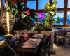 Ciao Chao
3 km
Für ein kurzfristig entschlossener Apero mit Lunch wurden wir trotz Skepsis wegen der...
Ciao Chao
3 km
Für ein kurzfristig entschlossener Apero mit Lunch wurden wir trotz Skepsis wegen der...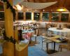 Pizzeria Sper Len
3 km
Sehr feines Essen zu sehr fairen Preisen. Vorallem Familien können sich hier zu einem...
Pizzeria Sper Len
3 km
Sehr feines Essen zu sehr fairen Preisen. Vorallem Familien können sich hier zu einem...Fügen Sie diese Karte zu Ihrer Website hinzu;

Wir verwenden Cookies und andere Tracking-Technologien, um Ihr Surferlebnis auf unserer Website zu verbessern, Ihnen personalisierte Inhalte und gezielte Anzeigen anzuzeigen, unseren Website-Verkehr zu analysieren und zu verstehen, woher unsere Besucher kommen. Datenschutz-Bestimmungen
